


 Email this Article
 Print
Print Download (PDF)
Abstract 
During
an ethnobotanical study in southern Ecuador, 354 species of wild
edible plants were recorded in 42 villages, sampled throughout the
different ecological areas. Edible plant species vary enormously from
one area to another, due to the diverse ecology of the region. When
analysing the number and species composition of 500 m interval
altitudinal areas, the highest number of edible plants was recorded
in the Amazonian area between 500 and 1000 m, an area with plentiful
forest resources and inhabited by Shuar. The second highest number of
edible plants was recorded in the dry coastal area between 1000 and
1500 m, an area intensely cultivated by small-scale mestizo farmers,
with very few forest remnants. Presence of natural vegetation is
therefore not necessary for wild plant use to occur. Here many wild
plants are managed within the agricultural system. At village level,
the highest numbers of edible plants per village were recorded in the
dry central part of Loja province, the higher western Andes and the
Amazonian lowlands. By analysing the similarity of wild edible plant
species between all 42 villages, using Dice similarity coefficients
and clustering analysis, eight areas with similar edible plants can
be identified in southern Ecuador. These roughly follow existing
ecological gradients. Major breaks in edible species composition
occur at 1000 m and 1600 m in the coastal area, at 1600 m in the
Amazonian area, and at 2500 m in the Andes. Some areas show
interesting plant composition anomalies.
Key words:
ethnobotany, ecology, Shuar, mestizo, similarity.
Resumen
Durante un estudio
etnobotánico en el sur del Ecuador, se recordaron 354 especies
de plantas silvestres comestibles en 42 pueblos, divididos sobre las
diferentes áreas ecológicas. Las especies de plantas
comestibles varían sumamente de una zona a otra, por la enorme
variabilidad ecológica en la región. Analizando los
números y especies de zonas de 500 m de altitud, números
altos de plantas comestibles fueron recordados en la región
amazónica entre 500 y 1000 m. Esta región tiene muchos
recursos forestales y es habitado por indígenas Shuar. El
segundo número más alto de plantas comestibles fue
recordado en la zona seca costera entre 1000 y 1500 m, una zona
cultivada intesamente por campesinos mestizos, con pocos remanentes
boscosos. No se necesita entonces presencia de vegetación
natural para uso intensivo de plantas silvestres. Aquí muchas
plantas silvestres son manejadas dentro del sistema agrícola.
A nivel de comunidad, los números más altos de plantas
comestibles fueron enregistrados en la parte central seca de la
provincia de Loja, la parte alta andina occidental y la zona baja
amazónica. Analizando la similitud de las plantas comestibles
de los 42 puebles, por medio de coeficientes de similitud (Dice) y
análisis de conglomerados, se pueden identificar ocho zonas
con plantas comestibles similares en el sur del Ecuador. Dichas zonas
siguen approximamente los gradientes ecológicos existentes.
Cambios majores en composición de especies comestibles ocurren
a 1000 m y 1600 m en la zona costera, a 1600 m en la Amazonía
y a 2500 m en la zona andina. Algunos lugares tienen una composición
excepcional en plantas.
Palabras clave:
etnobotánica, ecología, Shuar, mestizo, similitud.
Introduction
An inventory of wild edible plants was carried out in southern Ecuador from 1994 to 1997 (Van den Eynden et al. 2003). This region of roughly 30,000 km2, includes the coastal, Andean and Amazonian area (provinces El Oro, Loja and Zamora-Chinchipe). Altitude ranges from sea level at the coast, to 3800 m in the Andes, decreasing eastward in the Amazonian area to 800 m. Both the topography and climate can change over very short distances, resulting in a high species diversity and a large range of vegetation types (Best & Kessler 1995). Mangrove vegetation is found in some coastal areas, although most of this has been cleared in favour of shrimp farms and banana plantations. The coastal vegetation is generally dry in the southern part, ranging from deciduous to semi-deciduous shrub and forest vegetation. Further north, humid lowland and humid lower montane forest is found. In the Andes agriculture has replaced most of the original vegetation, which ranged from deciduous intermontane shrub and forest vegetation to humid cloud forest. Small forest remains are found in ravines and on steep slopes. Above 3200 m the vegetation consists of grass páramo. The eastern slopes of the Andes have cloud forest vegetation, becoming lower montane rain forest as altitude decreases (Best & Kessler 1995; Harling 1978). Timber logging and cattle farming threaten the vegetation in this area. Sixteen different life zones (following Holdridge's system) exist in southern Ecuador (Van den Eynden et al. 1999).
The population in southern Ecuador is mainly Mestizo, of mixed Spanish and indigenous descent, except for a small community of Saraguros (Quichuas) living in and around Saraguro in the northern Andes, and Shuar inhabiting the easternmost part of Zamora-Chinchipe province, along the Río Zamora, Río Nangaritza, Río Numpatakaime and their tributaries.
In the coastal lowland areas, agriculture is large-scale and mainly export-oriented. The main cash crops are bananas, coffee, shrimps (in the coastal waters) and cattle. In the Andes, small-scale traditional agropastoral farmers practise mainly subsistence agriculture. Alongside subsistence crops, small amounts of cash crops such as sugarcane, maize, peanut and coffee are grown. In the Amazonian region, the indigenous Shuar combine traditional agriculture, hunting and gathering, whereas immigrants (colonos) log timber and practise cattle farming and agriculture. The population in the coastal and Amazonian regions has risen sharply since the 1960s. Increasing immigration by colonos was caused by severe droughts in southern Ecuador and by national land reforms that encourage colonisation of the rainforest areas (Centro Andino de Tecnología Rural 1996; Pietri-Levy 1993). At the same time there is an increasing trend for rural people to abandon their land and go abroad as economic emigrants.
The inventory of wild edible plants was realised in 42 villages ([[Map 1]]), spread over the different ecological areas that exist in southern Ecuador. Information was obtained through interviews with random and key informants, and throuough botanical collection trips near each village. A total of 354 species of wild edible plants were recorded (Van den Eynden et al. 2003). Not all plant species recorded are stricly speaking wild. Management of non-crop plants by farmers is very important in the area. This means that certain native plants are tolerated or even cultivated within the agricultural system. Established crops and introduced species are, however, excluded from the inventory.
Methods
The regional and ecological variability of the species of edible plants that are used in the villages throughout southern Ecuador is explored here. This is deducted from the edible species mentioned and /or collected in the villages. The wild foods eaten in any one place are generally the species that grow locally. No major trade or exchange of fruits occurs between the different areas.
In order to analyse the variability in edible plant species that grow and are used in each village, a matrix was made listing all 354 plant species as rows and all 42 villages as columns. The edible species recorded for each village were indicated with presence/absence data (1 indicating presence, 0 absence).
The similarity between any pair of villages in terms of edible plant species, was calculated using the Dice similarity coefficient.
Dice coefficient DI=2a/2a+b+c
whereby a = the plant species is used in both villages 1 and 2; b = the plant species is used in village 1 but not in village 2; c = the plant species is used in village 2 but not in village 1 (Ludwig & Reynolds 1988). The Dice coefficient does not take double negatives (absence of a species in both villages) into account.
After calculating the similarity coefficient for each pair of villages, various methods of cluster analysis were performed on the similarity matrix, in order to find similar villages in terms of the wild edible plant species that are used. Unweighted pair-group method analysis (UPGMA; links a new item to the arithmetic average of a group), single linking (links a new item to the most similar item in a group), complete linking (links a new item to the most dissimilar item in a group) and neighbour unweighted joining, were performed using the statistical program NT-SYSpc-2.1 (Rohlf 2000). The clustering results are graphically presented with tree graphs. In order to test the goodness of fit for the clustering to represent the similarities between villages, the cophenetic value matrix was calculated for the resulting tree matrix, and compared with the original dissimilarity matrix. This comparison produces a cophenetic correlation coefficient.
Number and species variation was also considered for 500 m elevation zones, from sealevel to above 300 m, separating dry and humid areas. The split between the two corresponds to a mean annual precipitation of around 900-1000 mm. This results in 17 elevation zones for southern Ecuador (Figure 1). Dry areas only exist in the coastal area and in the western Andes up to about 2000 m altitude. Species variation was analysed by calculating Dice similarity coefficients for each pair of elevation zones.
Results
When considering the number of edible non-crop plant species recorded in each 500 m elevation zone, we find the highest number (104) in the Amazonian area below 1000 m (Figure 1). Not only is this a region where large parts of the original humid tropical forest vegetation are still intact, but also is this region inhabited by Shuar people, who generally use more plants compared to mestizos or colonos. The high number of edible plants in this area is thus a result of the large potential pool of edible plant resources, and the Shuar's extensive use and knowledge of wild plants. As the elevation increases in the Amazonian area, the number of edible plants decreases. This follows the general vegetation trend in Ecuador whereby species numbers decline with elevation (Jørgensen & Léon-Yánez 1999). At the same time, however, the higher areas in the Amazonian region are less populated, and no Shuar people live at higher altitudes. The decreasing use of edible plants with altitude in the Amazon results therefore from a combination of ethnical, botanical and population factors.
The area with the second highest number of edible species (66) is the dry coastal area between 1000 and 1500 m. An important difference with the previous area (lowland Amazon) is that here almost no original forest vegetation remains. This dry coastal area is intensely cultivated, but many wild species are managed within the agricultural system. This shows that the presence of high levels of natural vegetation is not necessary for wild plant use to persist in agricultural areas. In the dry areas, the number of edible plants decreases both with decreasing and increasing altitudes from this elevation zone. In the humid coastal areas, the number of edible plants generally follows the same trend as in dry areas, but absolute numbers are lower. This can be due to various factors. Humid coastal areas have been colonised more recently, so people may be less familiar with wild plants in these areas. Agriculture in humid areas focuses strongly on commercial cattle husbandry and banana plantations. Such farmers may have little interest in wild plants. And in southern Ecuador the overall humid coastal land area is smaller than the dry coastal land area. The third highest number of edible plants (59) is found in the western humid Andean area between 2500 and 3000 m. Here we again find fairly high levels of natural vegetation and the majority of edible plants used are wild.
Very low numbers of edible plants are found in the lower coastal wetlands (0-500 m). These areas have only recently been colonised and are largely under extensive banana plantations, so very few wild plants in general and edible ones in particular grow here. Another area with few edible species is the higher eastern Andes. Here the factor explaining such low number of recorded edible plants, is that this region is largely uninhabited, as was discussed earlier.
Edible plants in any 500 m elevation zone show the highest similarity to the species in the elevation zone just below or above ([[Table 1]]). The Dice coefficient for any two adjacent zones ranges from 0.27 to 0.46. The similarity of two elevation zones decreases rapidly as they are further apart in terms of elevation. Eventually zones have completely different edible species compositions (similarity coefficient near 0) when the elevation difference is more than 2000 m. This shows the large variability in edible non-crop plant species in southern Ecuador due to large differences in relief. Species that occur at low altitude are completely different from Andean species and vice versa.
The numbers and similarities of wild edible plants used in each village provide more detailed information on regional variations. The total of 354 species of edible plants were recorded in 42 different villages. The number of plants recorded per village ranges from 5 to 82, with an average of 19 plants per village. The number of plants used in each village varies highly ([[Map 1]]). The highest number of plants is used in the Río Nangaritza area. The Shuar here use 82 different species of wild edible plants. The second highest number (50 species) is found in the Casanga valley area in the dry premontane areas of Loja province. In general very few wild edible plants are found (and used) in the arid coastal areas. More plants are used in the more humid coastal areas. Areas with particularly high numbers of wild edible plants are the central part of Loja province, the higher western Andes and the low Amazonian area.
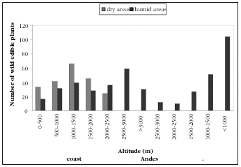
Figure 1. The
number of wild edible plant species found in 500 m interval elevation
zones throughout southern Ecuador.
Figura 1. Numero de plantas silvestres comestibles en intervalos de 500 m de elevacion en el Sur de Ecuador.
Figura 1. Numero de plantas silvestres comestibles en intervalos de 500 m de elevacion en el Sur de Ecuador.
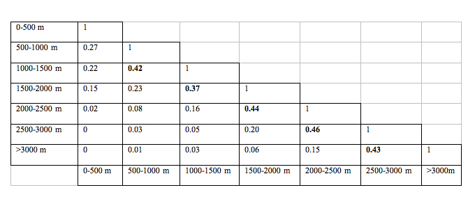
Table 1. The
similarity in wild edible plants between 500 m elevation zones in
southern Ecuador, indicated by the Dice similarity coefficients
(particularly high values are in bold)
Tabla 1. Similitud de plantas silvestres comestibles en 500 m de intervalos en el Sur de Ecuador, indicado por la similittud dice.
Tabla 1. Similitud de plantas silvestres comestibles en 500 m de intervalos en el Sur de Ecuador, indicado por la similittud dice.
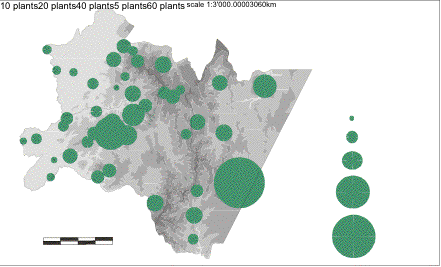
Map 1.
The number of wild edible plants used in each village.
Mapa 1. Número de plantas silvetsres comestibles en cada pueblo.
Mapa 1. Número de plantas silvetsres comestibles en cada pueblo.
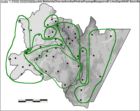
Map 2. Eight areas
with similar wild edible plant composition in southern Ecuador (based
on Dice similarity coefficients and UPGMA and neighbour-joining
clustering analysis) (derived from CINFA map).
Mapa 2. ocho areas con composicion similar de uso de plantas silvestres comestibles (basado en similitude Dice y UPGMA cluster y vecino cluster, derivado de papa CINFA).
Mapa 2. ocho areas con composicion similar de uso de plantas silvestres comestibles (basado en similitude Dice y UPGMA cluster y vecino cluster, derivado de papa CINFA).
When analysing the similarity in edible plants between the 42 studied villages, the UPGMA clustering method (Figure 2) produces a cophenetic correlation of 0.81, which means that the resulting tree (showing the similarities between villages in terms of wild edible plants used there) is a good fit of the reality. The single link and complete link clustering methods gave a lesser cophenetic correlation (0.54 and 0.71 respectively) and thus a lesser fit of the reality and are therefore not shown here. [[Fig. 3]] shows the result tree obtained via the neighbour-joining method. When comparing the two trees ([[Figure 2 and 3]]), clusters of villages with similar edible plants can be distinguished in southern Ecuador ([[Map 2]]).
Eight groups with similar edible plants can be distinguished. The villages that show the largest similarities in edible plant species are these in the arid coastal lowlands region (below 1000 m). This is the westernmost strip of El Oro province and the south-western part of Loja province (group 1). Isla Bellavista, Chacras, Zapotillo, El Sauce, Mangaurco, Puyango, Sabanilla, La Rusia and Tambo Negro have all very similar edible plants. The Dice similarity coefficient between any two villages ranges from 0.25 to 0.67. The highest similarity occurs between villages situated at similar altitudes. The larger the difference in altitude between two sites, the less similar the edible plants are. The vegetation in the nine villages is deciduous and semi-deciduous forest or dry shrubland vegetation. The edible plants that are used in all nine villages of group 1 (and that are therefore characteristic for this group) are the cacti Hylocereus polyrhizus (Weber) Britton & Rose and Monvillea diffusa Britton & Rose. All field sites selected for the dry coastal lowlands fall within this first group, except for Arenillas and Piedras. Arenillas has very few plant species similar to those of other villages in the dry areas. Its species are most similar to those of the humid area around Casacay (Dice coefficient 16%). The climate and vegetation in Arenillas seem therefore more humid than was thought. Even with Casacay, only few species are similar. The edible plants in Arenillas are overall very different from any other edible plant species in southern Ecuador, probably explained by its particular microclimate.
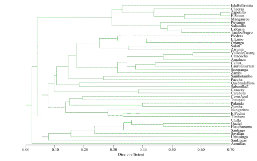
Figure 2. Tree plot
showing the similarity between villages in terms of edible plants
use, based on Dice similarity coefficients and the UPGMA clustering
method.
Figura 2. Árbol de similitude entre pueblos de acuerdoa las plantas silvestres comestibles usadas, basado en la similitude Dice y agrupamiento UPGMA.
Figura 2. Árbol de similitude entre pueblos de acuerdoa las plantas silvestres comestibles usadas, basado en la similitude Dice y agrupamiento UPGMA.
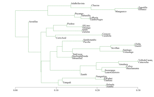
Figure 3. Tree plot
showing the similarity between villages in terms of edible plant use,
based on Dice similarity coefficients and the neighbour-joining
clustering method.
Figura 3. Arbol de similitude entre pueblos basado en la similaridad Dice con combinacion de vecindades.
Figura 3. Arbol de similitude entre pueblos basado en la similaridad Dice con combinacion de vecindades.
A second group of villages (group 2) that share similar edible plant species, are Piedras, El Limo, Orianga, Salatí and Zaruma, situated between 1200 and 1400 m (except for Piedras) in the central coastal area around the Puyango river. The climate is more humid compared to group 1 villages, the vegetation is semi-deciduous forest. Plant species in Piedras are most similar to those of more humid areas like Orianga and El Limo, but are also similar to species in the lower dry areas Puyango and Tambo Negro. Characteristic edible species for group 2 are Acnistus arborescens (L.) Schlecht., Bactris macana (Mart.) Pittier and Inga oerstediana Benth.
A third group is situated in the humid coastal lowlands below 1000 m (evergreen premontane vegetation) in the northernmost part of El Oro province. The similarity between edible species of Casacay, Carabota and Cerro Azul is 0.17 to 0.38 (Dice coefficient), which is fairly low. Characteristic edible species are Vasconcellea microcarpa (Jacq). A. DC. , Centropogon cornutus (L.) Druce and Wettinia kalbreyeri (Burret) R. Bernal.
At a slightly higher elevation (1200 - 1400 m), in the very humid coastal area of El Oro province and south of the previous group, lies a fourth cluster of villages with similar edible plants (group 4). This area has evergreen premontane and lower montane forest vegetation. Sambotambo and Paccha have a species similarity coefficient of 0.27. Characteristic edible plants for this group are Vasconcellea x heilbornii (Badillo) Badillo and Prestoea acuminata Willd.
In the central part of Loja province, a fifth group is situated in the dry to humid western Andes between 1200 and 2500 m elevation. Vegetation in this area includes dry shrubland, deciduous premontane forest, semi-deciduous lower montane forest and evergreen lower montane forest. The Casanga valley, Catacocha and Amaluza are fairly dry areas and have the most similar edible plant species (Dice coefficient 0.46-0.57). Celica, Lauro Guerrero, Sozoranga and Zambi (Dice coefficient 0.25-0.44) have a more humid climate. Characteristic edible species for this group are Annona cherimola Mill., Allophylus mollis (Kunth) Radlk., Vasconcellea x heilbornii (Badillo) Badillo, Inga striata Benth., Myrcia fallax (Rich.) DC. and Pouteria lucuma (R. & P.) Kuntze. Most of these are economic species.
A sixth cluster of villages with similar plants is situated in the higher Andes, at altitudes above 2500 m (group 6). Chilla, Gualel, Huachanamá, Santiago, Sevillán, Uritusinga and San Lucas all have a cold and humid climate. The area has evergreen (lower) montane forest and montane cloud forest vegetation. Plant species in Huachanamá, situated in the westernmost Andes range and separated from the remaining high areas of southern Ecuador by dry interandean valleys, show high similarity with species in this cluster and with species at lower altitude sites within the western mountain range (Celica and Lauro Guerrero). Characteristic edible species for group 6 are Vasconcellea x heilbornii (Badillo) Badillo, Hesperomeles ferruginea (Pers.) Benth., Macleania rupestris (H.B.K.) A.C. Smith, Passiflora matthewsii (Mast.) Killip, Rubus floribundus Kunth and Solanum caripense Dunal.
A seventh group of villages with similar edible plants is found in the higher parts of Zamora-Chinchipe province in the Amazonian area, between 1600 and 2000 m (montane cloud forest and montane evergreen forest vegetation). Quebrada Honda and Sabanilla have a Dice similarity coefficient of only 0.18 though. Characteristic edible species are Inga extra-nodis T.D. Penn. and Saurauia peruviana Busc.
A last group of villages with similar edible plants is situated in the lower Amazonian region, below 1600 m (group 8). One subgroup is the southern part of Zamora-Chinchipe province. Palanda and Zumba have a 0.40 similarity coefficient, They have evergreen lower montane forest vegetation. Timbara, El Padmi and the Río Nangaritza area form an eastern Amazonian lowland subgroup, with evergreen premontane and lower montane vegetation. Plant similarities between the latter three villages ranges form 0.25 to 0.33. Both subgroups have low similarity between them, probably because they are separated by the easternmost Andean cordillera. Edible plants in Tutupali are not very similar to those of the other Amazonian villages. Plants have a similarity of 0.22 with plants in El Padmi and Zumba and 0.20 with plants in Cerro Azul in the coastal wetlands. Characteristic edible species for group 8 are Bactris gasipaes H.B.K., Inga edulis Mart., Passiflora pergrandis Holm-Nielssen & Lawesson, Pouteria caimito (R. & P.) Radlk. and Rubus urticifolius Poir.
Conclusions
The wild edible plant species in southern Ecuador show a large variation throughout the region. This variation is determined by altitude and climate of an area, but also by socio-economic and ethnic factors. Certain areas like the Amazonian lowlands below 1000 m, the dry central part of Loja province (between 1000 and 1500 m) and the high western Andes between 2500 and 3000 m, seem hotspots with a particular high occurrence and use of edible plants. In the Amazonian lowlands, the availability of plant resources (forest vegetation) and the habitation by Shuar people can explain the abundance of edible plant use. For the other two areas, these explanations are not valid. Little natural vegetation is found in the dry central part of Loja province and the high western Andes. Another factor can explain the high number of edible plants here: plant management (Van den Eynden 2004). Many seemingly wild plants have been managed for centuries by farmers within the agricultural area, without necessarily being cultivated and domesticated. This has led to an increase in wild edible plants in these areas, and their survival in an intensily cultivated landscape. Many of these managed plants have a local commercial value.
In terms of species composition, eight areas with similar edible plant species can be identified in southern Ecuador. These areas generally follow the ecological gradients and vegetation types. Major breaks in species composition (as far as edible species are concerned) occur at 1000 and 1600 m in the coastal area, at 1600 m in the Amazonian area, and at 2500 m in the Andes. Dry and humid areas usually have their specific edible plant composition. Exceptions to this are the transitional group 2 around the Río Puyango watershed, and group 5 in central Loja, which combine areas with dry and humid climates. The central part of Loja province is characterised by a high percentage of economic edible plant species. This area has been cultivated for centuries by small-scale farmers. Native plants are actively managed within the agricultural system. Especially economic wild food plants are frequently managed.
Three areas (villages) do not follow the expected ecological gradients: Arenillas, Huachanamá and Tutupali. They do not belong neatly to any of the eight groups, which means that the plants here are different from what we would expect from the ecological conditions. The edible plants found in Arenillas are very different from the edible plants in any of the other areas of southern Ecuador. This may indicate that the overall vegetation in Arenillas is quite distinctive. The edible plants found in Huachanamá (situated at 3000 m in the westernmost Andean mountains), both show a similarity to the plants of nearby valleys, as to the plants of the mountain areas situated further east. The edible plants of Tutupali are quite different from the plants found in any other Amazonian areas. They are instead more similar to the plants found in the coastal wetlands. In vegetation classifications, however, the vegetation of the southern Amazon is classified as being fairly uniform. All three areas would deserve more detailed vegetation studies, since this study of wild edible plants indicates that their plant composition is quite exceptional.
Acknowledgements
I would like to thank the people of the villages and communities in southern Ecuador for sharing their knowledge and friendship with me, and Eduardo Cueva and Omar Cabrera for sharing the fieldwork and research. I thank everyone at the Centro Andino de Tecnología Rural (CATER) of the Universidad Nacional de Loja and at the Department for Tropical and Subtropical Agriculture and Ethnobotany of the University of Gent for their help in realising this project . Thanks to the people of the LOJA, QCA, QCNE, AAU and K herbaria for providing all facilities to identify the collected specimens. This research was partly supported by a VLIR (Flemish Inter-University Council) and VVOB (Flemish Organisation for Co-operation) grant. The Instituto Ecuatoriano Forestal y de Areas Naturales (INEFAN) in Quito kindly authorised the scientific research activities in the field and the collection of botanical specimens. The base map was produced by CINFA, Universidad Nacional de Loja in Ecuador.
References
Best, B.J. & M. Kessler. 1995. Biodiversity and conservation in Tumbesian Ecuador and Peru. Cambridge, BirdLife International.
Centro Andino de Tecnología Rural. 1996. Diagnóstico agro-socio-económico de la región sur. Loja, CATER, Universidad Nacional de Loja.
Harling, G. 1978. The Vegetation Types of Ecuador - A Brief Survey. In Larsen, K. & B. Holm-Nielsen. (eds). Tropical Botany, p 165-174. London, Academy Press.
Ludwig, J.A. & J.F. Reynolds. 1988. Statistical Ecology: a primer on methods and computing. New York, John Wiley & Sons.
Pietri-Levy, A. 1993. Loja, una provincia del Ecuador. Biblioteca de Geografía Ecuatoriana 4. Quito, Ediciones del Banco Central del Ecuador.
Rohlf, F.J. 2000. NTSYS Numerical Taxonomy and Multivariate Analysis System version 2.1 User guide. New York, Exeter Software.
Van den Eynden, V.; E. Cueva & O. Cabrera. 1999. Plantas silvestres comestibles del sur del Ecuador - Wild edible plants of southern Ecuador. Quito, Ediciones Abya-Yala.
Van den Eynden, V.; E. Cueva & O. Cabrera 2003. Wild foods from southern Ecuador. Economic Botany, 57(4): 576-603.
Van den Eynden, V. 2004. Use and management of edible non-crop plants in southern Ecuador. Doctoral dissertation. Gent, University of Gent.